The Painted Rocks site in Paint Rock, Texas, listed on the National Register of Historic Places, is one of the largest and most significant rock art sites in the United States. Stretching along the Concho River, a 70-foot limestone bluff served as a canvas for depictions of humans (anthropomorphs), animals (zoomorphs), geometric designs, and enigmatic figures. Approximately 1,500 paintings (pictographs) and etchings (petroglyphs) are spaced over 1,000 feet of the south-facing bluff. As the sun moves across the sky throughout the year, the jagged layers of the bluff create daggers of sunlight and shadow that interact with the pictographs. At least 50 align with solar events, such as solstices, equinoxes, and cross-quarter days, suggesting that the site served as a ceremonial calendar and place of ritual.
Indigenous and sojourning peoples were attracted to the Concho River and its environs. The chronicler of the 1650 Castillo-Martín expedition wrote:
“This river they call the Rio de los Nueces [Concho River] because it has along its bank and meadows many trees of this kind [pecan and walnut], besides mulberry trees, plum trees, wild grapes, and other fruits, and attractive resources growing along it. In its vicinity there are many wild cows which they call buffalo and many chickens on the land which in Spain, they call turkeys, and all kinds of deer.”
Besides these resources, cypress, cottonwoods, and elms provided materials for shelter, tools, and fuelwood. Mesquite, prickly pear, and herbaceous plants provided food and medicine. The river provided water, fish, and mussels and the bluff provided protection from cold northerly winds. Given these resources and its geographical location, the Painted Rocks served as a perpetual landmark and gathering place for people for thousands of years. They have also provided us with a vivid timeline of human presence in Texas. From early hunter-gatherers to the horse-centered cultures of the historic era, the site offers a rare window into the ways people lived, adapted, and expressed their beliefs. Today, the site stands not only as an archaeological treasure but also as a cultural and historical bridge, preserving stories that connect the past with the present. The Sims-Campbell family, together with the dedication of volunteers, researchers, archaeologists, tribal leaders, and generous supporters, have carefully preserved the site so that its unique history remains accessible to visitors from around the world and for generations to come.
Legacy is about what endures after presence and action fade away. The Painted Rocks is a legacy of traditions, stories, and practices of Indigenous peoples who once lived in west-central Texas. The Painted Rocks continue to shape their descendants’ identities.
Artifacts recovered on the Campbell ranch and surrounding counties date back thousands of years. Some of the pictographs were painted in these early periods by Indigenous peoples and those passing through. Fast forward to the Late Prehistoric period (AD 700 - ca. 1600). Archaeological evidence suggests that the limestone bluff was used extensively for painting during this time by groups related to the Jumano, who inhabited a large area of western Texas, New Mexico, and northern Mexico. The Jumano were bison hunters and traders, and played an active role as middlemen between the Spanish colonies and Indigenous groups throughout Texas and beyond. They traded with farming communities at La Junta de los Rios (near present-day Presidio), the Salinas Pueblos (near Mountainair) of New Mexico, and the Caddo of east Texas. They bartered bison hides and meat for corn, dried squashes, beans, salt, and other commodities. They obtained horses early, probably via their connections in New Mexico and northern Mexico, and may have been instrumental in introducing their use to the Caddo, Tonkawa, and other Texas groups. In the 1600s the Jumano repeatedly petitioned the Spanish authorities to establish missions in their homeland, seeking priests and soldiers to cement alliances and secure protection from the Apache. Despite their petitions, no permanent mission was established in Jumano territory. Spanish priorities lay elsewhere (New Mexico pueblos, East Texas missions), and by the mid-to late-1700s, the Jumano ceased to exist as a distinct people, assimilating into other groups such as the Comanche, Apache, Wichita, and Caddo. The Jumano had been a confederation of many small groups who may have spoken different languages, but all rooted in the Uto-Aztecan language family (Great Basin, California, the Southwest and western and central Mexico). They shared similar ideological beliefs and iconography. Pictographs attributed to them include the Winter and Summer Solstice markers, the Birth of the Hero Twins, the Equinox and Hummingbird panels, and the Decapitation scene.
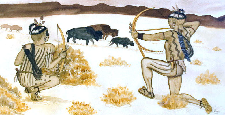
Artist Feather Radha’s depiction of Jumano Indians hunting bison. This 1994 painting can be seen in Restaurante Lobby's OK in Ojinaga, Mexico. Courtesy Elsa Socorro Arroyo.
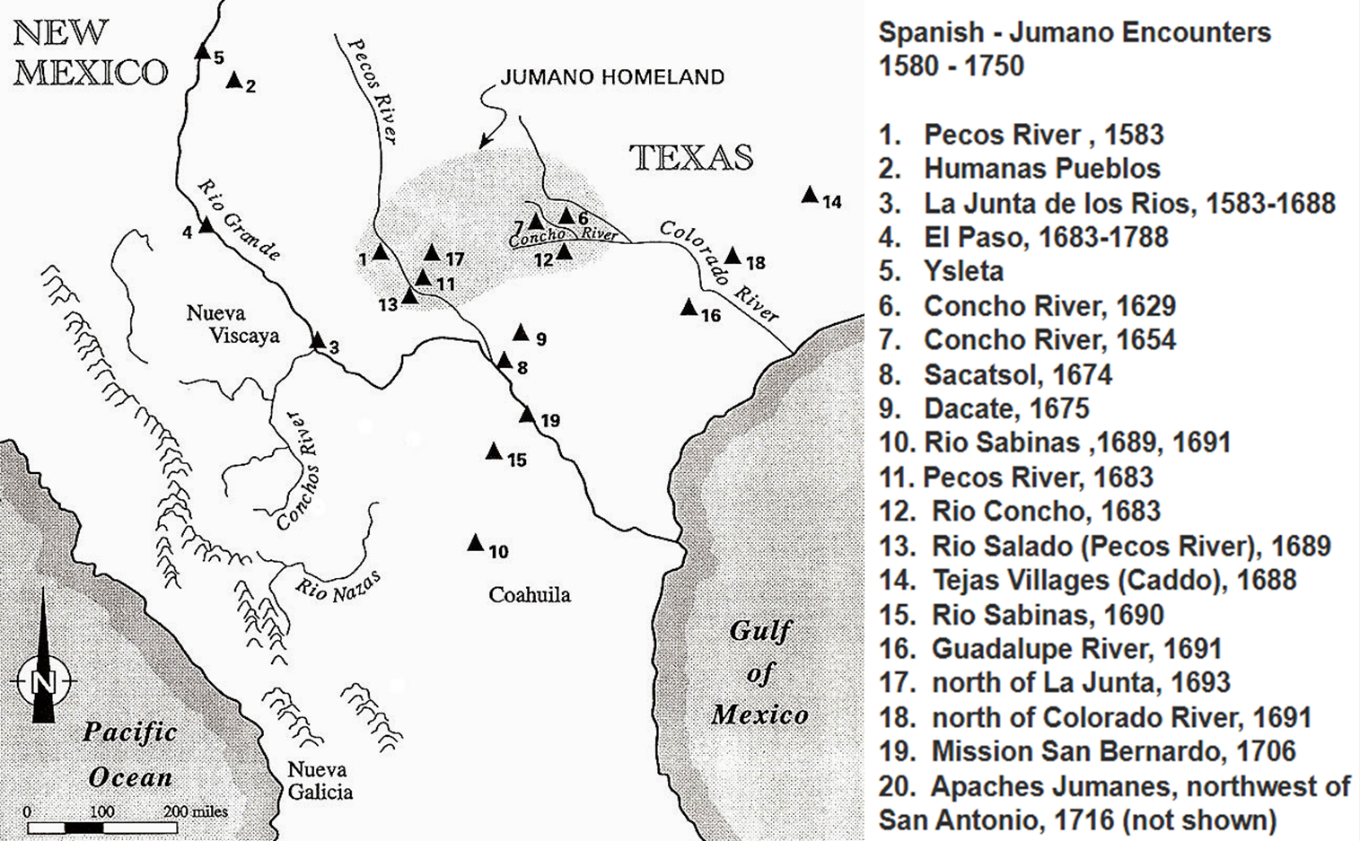
Map showing the original Jumano homeland as known from early Spanish encounters as well as locations where they were encountered then and later. From Kenmotsu 2001.
The Jumano sphere was disrupted when the eastern Apache (Lipan Apache), relative newcomers to the Southwest, began moving into the Southern Plains in the early 1600s. The Apache were Southern Athabascan speakers and their social unit was the extended family, led by a prominent member. Groups lived in close proximity and united for defensive or offensive purposes and for social or ceremonial occasions. They were hunters and gatherers and depended heavily on bison. The Apache were raiding Pueblos, Spanish settlements in Texas, New Mexico, and Coahuila, as well as Jumano rancherías in Texas. These raids, in conjunction with drought and Spanish oppression, led to the Pueblo Revolt in 1680, driving the Spaniards out of New Mexico. When the Spaniards reconquered New Mexico 12 years later, the Apache were a powerful nation of mounted warriors who raided with impunity. Their control extended eastward to the upper Brazos and Colorado rivers and southward into the lower Rio Grande valley. However, the Apache dominance was short-lived.
Painting, Lipan Apache encampment in Texas Hill County, by George Nelson. Image courtesy of Texas Beyond History.
The Comanche began entering northern Texas in the early 1700s after acquiring horses, which transformed them from a mountain-dwelling branch of the Shoshone into powerful Southern Plains nomads. Their mobility, access to bison, and trade opportunities drew them southward, challenging the Apache. They spoke a language belonging to the Numic branch of the Northern Uto‑Aztecan language family. Comanche society was made up of bands, which coalesced and broke apart, depending on the needs and goals of its members. The bison provided food, clothing, and shelter. Their diet was supplemented with wild roots, fruits, and nuts, or with produce obtained by trade with neighboring agricultural groups – Wichita, Caddo, and the Puebloans. They bartered bison products, horses, and captives for manufactured items and foodstuffs. For protection from the Comanche, the Apache asked the Spanish to provide a mission for them. In 1757, Mission Santa Cruz de San Sabá was established, but a year later, it was attacked by a force of 2,000 Comanche and their allies. The Apache retreated south and westward. By the late 1700s and into the 1800s, the Comanche controlled much of west, north, and central Texas, an area known as Comanchería until they were defeated in the Red River War by the U.S. Army in 1875. Paint Rock sat at the heart of Comanchería.
As many as thirteen different Comanche bands were identified during the historic period. The southernmost band was the Penateka, or “Honey Eaters.” Their range extended from the Edwards Plateau to the headwaters of the central Texas rivers. The Penateka played a prominent role in Texas history. Pictographs and petroglyphs at Paint Rock – horses, bison, teepees, scenes of conflict, a honeycomb and bee composition, names of chiefs, and the destruction of the San Sabá mission – have been attributed to the Comanche.
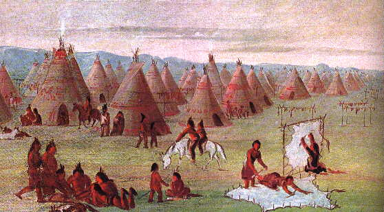
Painting, Comanche Village by George Catlin, 1834, courtesy of the Texas State Historical Association.
Other groups, such as the Tonkawa and Kickapoo, Texas Rangers, U.S. Army, surveyors, and cattlemen also passed through, drawn by the same resources and the same natural gathering place that had attracted earlier peoples. Its bluff provided a pallet for human expression, its river sustained life, and its position on the landscape ensured it would remain a gathering point for centuries. Today, the site not only serves as a historical record, but also as a visual record of cultural beliefs, daily life, and sacred cosmologies. The Painted Rocks is a legacy of those who came before and has been entrusted to us to protect and preserve.
The archaeological chronology for the region is based on projectile point technology, changes in climatic and environmental conditions, and adaptive changes in subsistence strategies. A brief summary of the archaeological periods for this area of Texas is presented here.
Paleoindian Period (11,500 - 6,000 BCE)
The Southern Plains contain three Paleoindian sites with in situ evidence of occupation. Blackwater Draw (across the border in New Mexico) has yielded the most evidence of Clovis occupation in North America, including the remains of mammoth, horse, camel, and bison. Remains of mammoth found in association with Clovis tools were also found at the Miami site, located in the Texas Panhandle. In addition, the Lubbock Lake site contains distinct Clovis and Folsom deposits, representing mammoth scavenging and bison hunting activities. The Paleoindian Period projectile points include Angostura, Dalton, Plainview, and Scottsbluff types. The oldest artifact found on the Campbell ranch is a broken Angostura point. Angostura points date to the Late Paleoindian period, circa 8,000 - 6,000 BCE.
Archaic Period 6,000 BCE - AD 700)
The Archaic period in Texas is divided into three subperiods – Early, Middle, and Late – because it spans thousands of years and shows major shifts in climate, bison presence, subsistence strategies, and material culture.
Early Archaic Period (6,000 - 4,000 BCE)
The Early Archaic climate was warmer and drier than the preceding Paleoindian period. This reduced the availability of large game, expanded grasslands and scrub environments, and pushed human groups toward broader foraging strategies. Small, mobile hunter‑gatherer groups hunted animals such as deer, antelope, and rabbits, and gathered plant foods such as tubers, nuts, berries, and seeds. They established campsites near rivers, springs, and ecotones (transitional zones between environments). Groundstone tools – metates (mortars) and manos (pestles) – were used to process seeds and nuts. Early Archaic peoples began using earth ovens to cook foods. Projectile points evolved from Paleoindian fluted forms to corner‑ and side‑notched dart points such as Early Split Stem, Gower, and Martindale types.
Middle Archaic Period (4,000 - 2,000 BCE)
During the early part of the Middle Archaic period, the climate was somewhat mesic and bison returned. Bell, Andice, and Calf Creek dart points may have been part of a specialized bison weaponry brought to the region by groups from the northeast. During the later part of the Middle Archaic period, xeric conditions returned and bison disappeared. Populations increased despite the fact that the climate worsened. Groups moved across ecological zones to harvest different plants at peak times. Subsistence during this period included an increased reliance on tubers (geophytes) and succulents (xerophytes), which required labor‑intensive processing in earth ovens. A hallmark of this period is large accumulations of fire‑cracked rock from repeated plant baking in earth ovens, known archaeologically as burned-rock middens. Prey included deer, antelope, rabbits, and turkey. Projectile points of this period include Nolan, Pandale, Pedernales, and Travis types. On the Campbell ranch, archaeologists have found three burned-rock middens and associated mussel shell, lithic debitage, scrapers, and a Travis dart point.
Archaeological evidence and rock art stylistic motifs reveal that Indigenous peoples of west-central Texas were connected to distant groups via trade networks and possibly marriage alliances. Nonlocal lithic material and marine shell (from the Gulf of Mexico or the Pacific) have been recovered from Middle Archaic sites in surrounding counties. During this time, in the Lower Pecos River Canyonlands, Indigenous peoples were depicting their creation narratives on the walls of rock shelters. Similar motifs of the Pecos River style (5,700 - 2,000 years old), have been identified on the Painted Rocks limestone bluff; a good example is the Torches panel.
Late Archaic Period (2,000 BCE - AD 700)
The Late Archaic climate was generally warm and dry, with notable fluctuations of rainfall that influenced vegetation and water availability. Shifts between grassland and scrub affected bison presence, leading to heavier reliance on small game, fish, and seasonal plants. Groups reoccupied favorite campsites near rivers and springs. Earth ovens were widely used to cook geophytes and groundstone tools were used to process nuts and seeds. Because of overlapping ecological zones, increased regional specialization, and population movements, Late Archaic projectile point types were remarkably diverse across Texas. Types common to west-central Texas are Darl, Ensor, Frio, and Marcos. On the Campbell ranch, a Late Archaic campsite, defined by a scatter of burned rock and Marcos (600 BCE - AD 200) and Frio (200 BCE - AD 600) dart points was encountered; suggesting two occupations on the property during this period.
Late Archaic peoples adapted to climatic variability by engaging in trade and food exchange with adjacent regions as a strategy to mitigate against periods of resource scarcity. These interactions may have also involved sharing information, forming alliances and gift-giving, exchanging marriage partners, and participating together in rituals. Marine shell beads (sourced to the Gulf of Mexico or the Pacific) and a grayish-green slate gorget (pendant worn at the neck) sourced to western Arkansas have been recovered from sites in Concho County, as well as a Marcos dart point fashioned from chalcedony, sourced to the Trans-Pecos region. The Pecos River style rock art of the Lower Pecos continues, revealing an ancient and wide-spread ideology. In short, the Late Archaic period represents a mature hunter-gatherer adaptation, with technological innovation, expanded diets, and more complex social practices.
Late Prehistoric Period (AD 700 - ca. 1600)
A shift from the Archaic to the Late Prehistoric Period was noted by technological change – the adoption of the bow and arrow and the introduction of pottery. In the central region of Texas, the Late Prehistoric is divided into two temporal phases – Austin and Toyah.
Austin phase (AD 700 - 1350) peoples often reoccupied Late Archaic period campsites and reused earth ovens, showing continuity with earlier lifeways. They relied on hunting and gathering, with deer and small game as staples, and continued with earth-oven cooking. The corner-notched Scallorn arrow point is diagnostic of the Austin phase. This point was widespread, linking Indigenous peoples with Woodland cultures of the Midwest and Puebloans in New Mexico. Two Scallorn arrow points made from white novaculite, sourced to the Ouachita Mountains in western Arkansas, were recovered from Austin-phase sites in Concho and Runnels counties. Two other Austin-phase arrow points found in west-central Texas are Chadbourne and Moran types. A Chadbourne arrow point was recovered from the river terrace on the Campbell ranch.
During the Toyah phase (AD 1350 - 1600), bison returned to the Southern Plains and central and south Texas, but deer and small mammals remained common prey. Highly mobile hunter‑gatherers set up short‑term campsites and foraged for plant foods to supplement their diets. A shift in technology also occurred, characterized by the introduction of blade technology, the contacting-stem Perdiz arrow point, alternately-beveled bifaces, and Leon Plain ceramic vessels. These vessels were undecorated, bone-tempered bowls, jars, and ollas. Analyses of residues from sherds suggest that vessels were used to process bison and deer bone grease. They were also used to hold a highly-caffeinated Yaupon Holly tea (Ilex vomitoria), which was probably consumed in rituals. Toyah groups, including the Jumano, interacted with Puebloans in New Mexico, the Caddo in East Texas, and mobile groups in northern Mexico.
The river terrace on the Campbell ranch was also occupied during the Toyah phase. Bison bone, Perdiz arrow points, distinct Toyah stone tools, and Leon Plain ceramic sherds were recovered in test excavations, along with mussel shell and fire-cracked rock. In addition, two nonlocal ceramic sherds were found. The first represents a micaceous ceramic ware (consisting of quartz, feldspars, and mica temper of volcanic origin), distinctive to the middle Pecos River valley of eastern New Mexico or possibly the Llano Uplift region of central Texas. The second is represented by an incised, sherd-tempered Caddoan specimen from east Texas. In the surrounding counties, other nonlocal ceramics were recovered – a polychrome bowl sherd, typed to the upper Rio Grande valley, and a sand-tempered sherd, similar to El Paso Brownware of southeastern New Mexico.
The Historic Period is marked by the first written accounts of European contact with Indigenous groups. It also includes the Archaeological Toyah Phase of the Late Prehistoric Period.
Circa 1535 – Cabeza de Vaca, a Spaniard shipwrecked near Galveston in 1528, ventured west, seeking to return to the Spanish colonies in Mexico. De Vaca encountered various groups, including Jumano at La Junta de los Rios (present-day Presidio).
After this time, Spanish explorers note the presence of Jumano north of the Rio Grande and as far west as the pueblos in New Mexico.
1582 - 1583 – The Espejo–Luxán expedition led by Antonio de Espejo and chronicled by Diego Pérez de Luzán, was launched primarily to find two missing Franciscan missionaries in New Mexico, but it quickly expanded into a broader reconnaissance of peoples, resources, and potential mission sites in the northern frontier of New Spain. While at La Junta, the expedition encountered the Patarabueyes and other peoples, possibly the Jumano. The group traveled north along the Rio del Norte (Rio Grande), westward into Arizona, visiting the Zuni and Hopi pueblos. On the return home, the expedition took a different route – southward along the Pecos River (Espejo called it the “Rio de las Vacas” because of the large number of bison encountered). The expedition came upon a Jumano ranchería (near present-day Pecos, Texas, upstream from the junction of Toyah Creek on the Pecos River) and shared a large meal with them. The Jumano then guided them across the country to La Junta.
1591 or 1598 – The first Spanish (or Portuguese) graffiti appears on the bluff, potentially linked to the Gaspar Castaño de Sosa expedition. Castaño de Sosa was a Portuguese-born Spanish official, who launched an unauthorized expedition into Texas in 1590. The expedition encountered Jumano living along the Pecos River, who gave them bison and antelope hides, shoes, and meat.
1629 – Approximately 50 Jumano arrived at Mission San Antonio de Padua at Isleta Pueblo (13 miles south of present-day Albuquerque), led by Jumano captain Tuerto, to ask that priests be sent to their homeland. They informed the Spaniards that they were following the instructions of a lady wearing a blue cloak (Lady in Blue, María de Jesús de Ágreda) who appeared to them many times and taught them the basics of Catholicism. Fray Juan de Salas and Fray Diego de León accompanied them back to their homeland along the “Nueces River,” likely the Concho River (the Concho River was lined with pecan trees) and spent many months instructing and baptizing the Jumano and their allies.
1632 – Fray Salas returned to the Jumano homeland near present-day San Angelo, with Fray Juan de Ortega. Ortega spent six months with the Jumano.
1650 – The Spanish governor in Santa Fé requisitioned an exploration of Jumano lands. Diego del Castillo and Hernán Martín led the expedition. They were accompanied by Christianized Indigenous peoples (probably Jumano from the Salinas Pueblos) and stayed for six months along the Concho River, calling it the Rio del as Perlas (River of Pearls). While there, they found large quantities of freshwater mussels in the river that contained pearls. Samples of the pink and purple-toned pearls were sent back to Spanish officials in Santa Fé, generating excitement for a new industry on the northern frontier.
1654 – To follow up on Castillo’s findings, the Diego de Guadalajara expedition, which included 30 soldiers and 200 Christianized Indigenous peoples, was sent to the Jumano homeland to harvest pearls. A group under the command of Andrés López, traveled 80 miles to the east and battled the Cuitoa people, taking prisoners and a large quantity of animal skins. Although the expedition did not obtain as many pearls as it had wished; it returned to Santa Fé will skins and slaves. A member of the expedition, Juan Domínguez de Mendoza, would later lead an expedition into Jumano territory.
Late 1600s - mid-1700s — Lipan Apache leave evidence of occupation (and paintings) at the Paint Rock site and continue to visit the site until the mid-1700s.
1673 - 1678 – The pueblos in the Salinas district were abandoned because of Apache raids.
1680 - 1692 – The Pueblo Revolt (Po’pay’s Rebellion) killed 400 Spaniards and drove 2,000 settlers out of present-day New Mexico. The Spaniards retreated to El Paso del Norte. Conditions were dire – drought, crop failures, threats of revolt and unrest, epidemics, and Apache raids.
1683 – Juan Sabeáta, a Jumano cacique (chief), baptized in Nueva Vizcaya, arrived in El Paso with 12 Jumano captains, seeking an alliance with the Spaniards. They requested missions as well as military aid against Apache aggression. In return, the Jumano would provide the Spaniards with badly needed provisions, organize trade fairs with 36 nations along the Concho River, offer lands for settlement, and provide introductions to the Tejas (Caddo) in the east. Sabeáta also informed the Spaniards of European traders in east Texas (two years before La Salle landed on the Texas coast).
1683 - 1684 – In response to Sabeáta’s request, the new Governor, Domingo Gironza Petriz de Cruzate, organized an expedition into the Jumano homeland and appointed Juan Domínguez de Mendoza as the leader of the Mendoza-López Expedition. Fray Nicolás López served as the senior missionary and Sabeáta served as the Indigenous guide and political broker. The aim of the expedition was to re‑establish Spanish influence after the Pueblo Revolt, evaluate Indigenous requests for missions, and explore and document the region’s geography and peoples. The expedition left El Paso and traveled to La Junta where a few missionaries stayed for a short time. The rest of the expedition followed trails northeast to the Pecos River. At the Gediondo ranchería (allies of the Jumano, located in present-day Crockett County), the expedition was welcomed with a display of a wooden cross, painted red and yellow, and a white taffeta flag displaying blue taffeta crosses. After spending five days, the party traveled eastward to the Middle Concho River, following it downstream toward its junction with the Colorado River, but did not stay long. The expedition traveled south, avoiding the lower Concho-Colorado confluence for fear of Apache attack. The group spent six weeks on what Mendoza called the “glorious San Clemente” river (San Sabá River) and built a two-storied adobe fort/church for defense against the Apache and hunted bison for hides and food. Mendoza and Sabeáta clashed and the expedition was abandoned. The Spaniards returned to El Paso with 5,000 hides.
1689 – While on the Pecos River, Sabeáta informed General Retana of the destruction of the French settlement (Fort Saint Louis) and later testified before Governor Pardiñas in Parral. This news was later confirmed by the exploratory expedition of Alonso de León.
1706 – The Spaniards documented Comanche (and Ute) raids near Taos, New Mexico, and along the Rio Grande.
1718 - 1731 – The Spanish established missions in San Antonio (San José, Concepción, San Juan, Espada) for the Coahuiltecan and other displaced groups. A Guerrero arrow point, dating to the Mission Period was recovered from the river terrace on the Campbell ranch. Guerrero arrow points are associated with Spanish colonial mission sites and Indigenous groups in northern Mexico and southern Texas.
1757 – Mission Santa Cruz de San Sabá and Presidio San Luis de las Amaríllas, near present-day Menard on the San Sabá River (approximately 37 miles south of Paint Rock), were established to missionize and protect the Lipan Apache after signing the Treaty of Mission Valero de Béxar in 1749.
1758 – The Comanche and their allies destroyed Mission Santa Cruz de San Sabá. The Comanche became the primary occupants of the Concho River valley and the Paint Rock site for approximately the next one hundred years.
1762 - 1769 – Two missions – Mission San Lorenzo de la Santa Cruz and Mission Nuestra Señora de la Candelaria (Camp Wood, Texas on the upper Nueces River) – were founded to missionize the Lipan Apache who had requested Spanish alliance. Both missions were abandoned due to Apache-Comanche conflict, disease, and lack of stable settlement.
1770 – Presidio San Luis de las Amaríllas was abandoned, the same year Spain permanently withdrew from the San Sabá frontier.
Circa 1820 – The Kickapoo, an Algonquin-speaking tribe from the Great Lakes region, seeking to avoid European contact, ventured to the Paint Rock area, and may have visited the site over the next few decades.
1846 – Approximately 40 Texas Rangers, led by Captain Jack Hays, (supposedly) ambushed a Comanche war party near the Paint Rock site. This battle marked a negative turning point in relations between the Comanche and the state of Texas.
1852 – The U.S. Army established Fort Chadbourne near present-day Bronte, north of the Paint Rock site, and Fort McKavett near present-day Menard.
1856 – Lt. Col. Robert E. Lee led four companies (200 soldiers) of the U.S. 2nd Calvary on a sweep of the Concho River in search of the Comanche to “cleanse the plains west of the reserves of Indians.” Paint Rock was chosen because it was midway between Forts Chadbourne and Mason. Detachments were deployed to locate the Penatekas. Many U.S. Army detachments camped at Paint Rock when the forts were in use and some left their names among the pictographs.
1867 – The U.S. Army established Fort Concho in present-day San Angelo. The Army abandoned Fort Chadbourne that same year and Fort McKavett the following year, but reoccupied Fort McKavett when conflict with the Comanche intensified.
1877 – After traveling from Missouri, D. E. Sims acquired land along the Concho River in order to safeguard the pictographs.
1886 – Sims owned about 14,000 acres, including the Paint Rock site.
1927 – Cora Ellen “Kay” Sims was born on August 12.
1930s – The Sims family began offering tours to the public. In 1933, A. T. Jackson of the University of Texas contacted the Sims family about the Paint Rock pictographs and the family assisted him document the pictographs. Rock art illustrator Forrest Kirkland and his wife Lula visited the site in 1933-1934 to record the paintings, thus beginning their mission to document rock art sites across Texas. The Paint Rock water colors became some of the earliest professional records of pictographs in the state.
1954 – Kay inherited the Paint Rock site along with other land. Members of the Paint Rock community, such as Bill Warren, assisted with tours.
1971, June 21 (summer solstice) – The site of Paint Rock (41CC1) was listed on the National Register of Historic Places. The nomination was prepared by Wayne Bell, Project Director, and Marsha Jackson, Research Associate, of the Texas State Historical Survey Committee.
1979 - 1993 – In 1979, prior to construction of O.H. Ivie Reservoir, a pedestrian survey of the basin was conducted and over 300 prehistoric sites were recorded. In 1988, an archaeological firm was selected to investigate the cultural resources within the basin. Forty prehistoric sites were selected for test and full data recovery was conducted at six preceramic sites and three ceramic sites. Nine of these sites yielded ceramic sherds, lithic materials, marine shell, and groundstone tools originating from outside west-central Texas. The report was published in 1993. Christopher Lintz, PhD, served as principal investigator: Cultural Resource Investigations in the O. H. Ivie Reservoir, Concho, Coleman, and Runnels Counties, Texas, Volumes 1-IV (Mariah Associates, Inc.).
1987 – Kay and Fred, along with sons, Scott and Bill, established Paint Rock Excursions, Inc., to operate the site. Paint Rock community member Dan Webb, assisted with tours.
Late 1980s - 1990s – Kay and Fred Campbell identified solar alignments in the pictographs (first the equinox “Sunshine Path” and then the winter solstice “Flower Shield”). During this time, Kay and Fred invited researchers such as Robbin Robbins, Solveig Turpin, and Linda Pelon to conduct research at the site.
1993 – Kay and Fred hosted leaders from the Comanche Nation, including Wallace Coffee, Phillis Narcomey, and others to the site in December, close to the winter solstice.
1999 - 2000 – Archaeological survey and testing were conducted by Solveig Turpin, Larry Riemenschneider, David Robinson, and the Concho Valley Archeological Society. Fourteen sites were located on the Campbell property. Results were published in Current Archeology in Texas (Texas Historical Commission 2002).
2001 - 2002 – The Rock Art Task Force of the Texas Archeological Society spent two seasons at Paint Rock, mapping, photographing, drawing, and rendering in watercolor the pictographs.
2004 – The Texas Historical Commission honored Kay and Fred Campbell with a Historic Texas Lands Plaque in recognition of their support of archaeological research on their property.
2009 - 2010 – Metal detecting, electromagnetic induction survey, and test excavations were conducted by Texas A&M University and the Concho Valley Archeological Society to identify areas and recover artifacts of pre- and post-Civil War military conflict. The report, The Battle that Was and the Battle that Wasn’t, Historical and Archaeological Investigations at Paint Rock, Texas, by Timothy S. Smet, D. Bruce Dickson, and Mark E. Everett was published in The Archaeology of Engagement, Conflict and Revolution in the United States, Dana L Pertermann and Holly Katheryn Norton (Texas A&M University Press 2015).
2017 – Fred Campbell passed away; Kay continued as lead steward. Over the next few years, Kay and Bill began working with Kim Cox, Jeremy Elliott, PhD, and Eric Schroeder, PhD, on site research. Paint Rock community member Terry Waller assisted with tours.
2018 - present – Kim Cox continues to conduct research on individual and compositional pictographs and petroglyphs at Paint Rock. His ever-growing Guidebook to the Art and Light of Paint Rock, Texas (41CC1) includes photographs and D-Stretch renderings of the major pictograph panels, as well as descriptions and interpretations.
2023 - 2026 – The Paint Rock Community Collaboration Project, under the direction of Eric Schroeder and Jeremy Elliott, brought Native American communities and archaeologists together to collaborate and learn from each other about the land and the history of Paint Rock. Held on the spring equinox, the four-year, five-day project included archaeological excavations at site 41CC295 (river terrace), laboratory processing of artifacts, and pedestrian surveys. Storytelling, stone- and fiber-tool making, educational workshops, and Native American cooking brought everyone together each day.
2024 – Kay Campbell passed away. Son, Bill Campbell, and his sons, Auggie Campbell and John Campbell, along with her grandchildren, Jill Campbell Reed and Steven Campbell, carried on the family legacy of caring for and preserving the site. Bill Campbell continued tours, operated through Paint Rock Excursions, Inc.
2025 – The Painted Rocks Historical Site, Inc., a 501(c)(3) organization, was founded in order to carry on the family legacy – to protect and preserve the site, to offer educational programs, and to conduct scholarly research.
